‘Mess of a storm’ arrives in the GTA, record rain and potentially record snow

Posted December 1, 2020 6:28 am.
Last Updated December 1, 2020 6:43 am.
Winter weather has arrived as we start the month of December.
Toronto saw a record rainfall on Monday with the potential for a record snowfall on Tuesday.
Special Weather Statements have been issued for Northern York and Durham regions along with Caledon for a healthy amount of snow over the next couple of days. Snowfall warnings have been issued for Barrie-Orillia-Midland and Dufferin-Innisfil.
An enormous low-pressure system brought steady rain to the region on Monday afternoon and evening. Rainfall totals at Toronto Pearson Airport were 18 mm. This breaks the Nov. 30, 2006 record of 17.6 mm.
“Snow days” will look a little different this year, with online learning already a big part of this year’s curriculum due to the pandemic.
Snowy start to December! Roads north of Major Mackenzie are snow covered this morning. Snow continuing on & off through today into Wednesday, GTA 2-5cm, Hamilton 5-10cm, Barrie 10-15cm, Collingwood 15-25cm. GTA High 2c, wind N 20-40 km/h. @BTtoronto #citywx pic.twitter.com/yXAcd6DQf0
— Frankie Flowers (@FrankFerragine) December 1, 2020
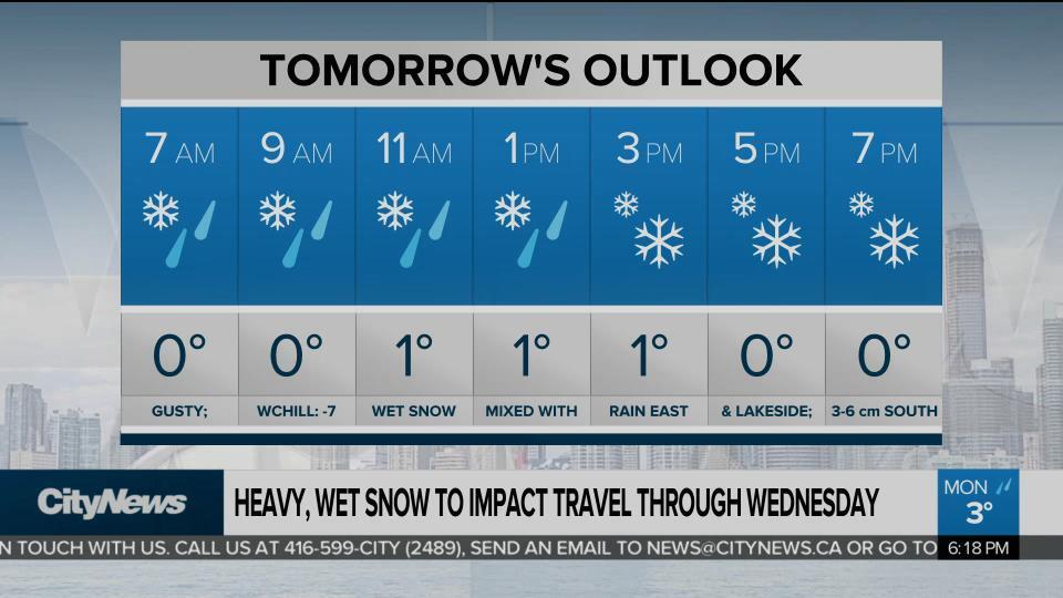
For those in downtown Toronto, the change from rain to heavy wet snow happened during the overnight. Residents woke up to a coating of snow on their windshield and lawn. Temperatures dropped to an overnight low of 0 C.
Once the winds change direction, we will be picking up some lake enhancement, which will only intensify the snow across the region. Everyone will see snow on Tuesday from Barrie to King City and from Uxbridge to Mississauga. Another concern will be the blowing and drifting snow, with gusting wind, that will reduce visibility at times.
The low-pressure system will stall out and hover over our region for a period of time on Tuesday, which allows for more snow to fall. The snow continues for Wednesday but will start to ease as we head into the afternoon and evening. However, it will be windy, which will make visibility a challenge again.
Total accumulations for the entire storm will vary by location. Areas right along Lake Ontario can expect about five to seven centimetres of snow, seven to 15 centimetres for Markham, Thornhill, Woodbridge, Stouffville, and 20 to 25 centimetres for Orangeville, Shelburne, and Mount Forest.
Some areas in and around Georgian Bay like Blue Mountains, Singhampton, and Collingwood will see anywhere between 30 to 50 centimetres.


