Special weather statements, warnings ended for Toronto and GTA

Posted August 21, 2022 9:22 am.
Last Updated August 21, 2022 11:32 pm.
A number of weather statements and warnings for Toronto and the GTA have ended after a weather system passed through the region, dumping a large amount of rain and leading to localized flooding in some areas.
Environment Canada said upwards of 40 mm of rain was possible over northern portions of Toronto this evening while a stationary weather system dropped more than 100 mm of rain over Brampton and southern Caledon. Some reports indicated north Brampton had received more than 200 mm of rain over the past two days.
Heavy Rain Causing Floods In Brampton.
.#Brampton #rain #storm #onpoli #peel #Toronto #Mississauga #WeatherUpdate #trucking #TruckDriver #flooding pic.twitter.com/l6u8jaA0GJ— 401_da_sarpanch (@401_da_sarpanch) August 22, 2022
A special weather statement remains in effect for Vaughan, Richmond Hill, Markham and the rest of York and Durham region.
“These showers are slow moving and may continue to redevelop throughout the evening,” said the national weather service. “Local rainfall amounts of 20 to 50 mm are possible through this evening.”
Severe thunderstorm warnings were still effect for Barrie, Collingwood and Orillia where local rainfall amounts of between 50 to 100 mm were possible.
“Localized heavy rainfall continues into this evening due to a cluster of nearly stationary thunderstorms,” said Environment Canada. “Radar estimates indicate that some locales in Barrie have already seen 60 to 90 mm of rain. Local reports of flooding have been reported from Barrie as well.”
Grove Street in #Barrie, Ontario. Storm Sewers overwhelmed. About 30 minutes of heavy rain so far. The odd loud crack of thunder too #ONstorm #ONwx @weathernetwork @StormhunterTWN pic.twitter.com/6icOfq6d1H
— no3putting (@no3putting) August 21, 2022
The Toronto and Region Conservation Authority is warning of the potential for higher than normal water levels within GTA lakes and rivers until Tuesday morning due to widespread showers and thunderstorms across the region
Toronto is not expected to have a break from the wet weather until Wednesday, with the weather agency forecasting a chance of showers and a risk of a thunderstorm throughout the day and evening on Sunday and Monday, and a chance showers for Tuesday.
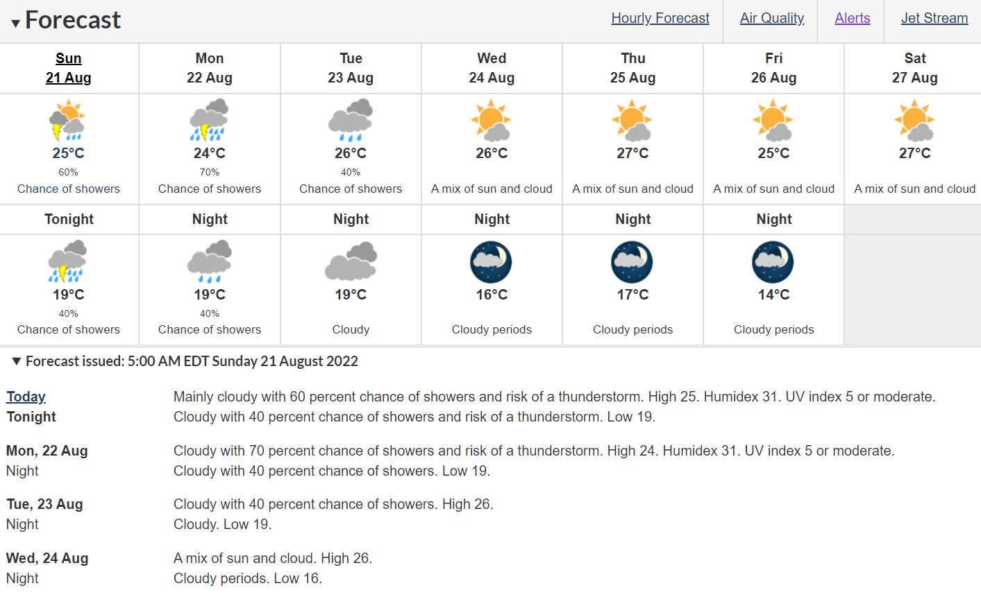
Environment Canada is calling for widespread showers and thunderstorms for the region over the next couple of days. (Environment Canada screen grab August 21, 2022).
“These showers may also bring additional precipitation from embedded thunderstorms. Rainfall from these thunderstorms is expected to occur off and on throughout the daytime, evening and overnight hours,” the TRCA said in a statement.
“The potential exists for multiple thunderstorms to occur in the same location and could result in localized rainfall amounts of up to 50mm by the end of Sunday. Additional rain is expected throughout Monday.”
On Sunday morning, it said TRCA watersheds have already received between between five to 20 mm of rainfall and 53 mm of rain in the northern Etobicoke Creek watershed over the past 24 hours.
The TRCA said because of the rainfall on Saturday and in the early hours on Sunday, ground conditions are saturated and some watercourses are flowing higher than what’s considered normal.
“Although flooding is not expected, all rivers within the GTA may experience higher flows and water levels due to rainfall and thunderstorm activity today and tomorrow,” the TRCA said, “The combination of slippery and unstable banks, and rising water levels could create hazardous conditions near rivers or other water bodies.”
It also warned poor visibility and ponding of water in low lying areas, and in areas with poor drainage, could be the result in areas receiving more rain from thunderstorms.
The TRCA is advising the public to avoid recreational activities in and around water, as well as to exercise caution around bodies of water, as this warning is in place.
“Avoid areas already experiencing erosion or blockages with debris,” it said, “Please alert any children under your care of these dangers and supervise their activities. Please keep children and pets away from banks as they may be slippery and unstable.”
Due to rainfall already received and forecasted rainfall and thunderstorm activity today, watercourses are expected to be flowing higher than normal. Stay clear of watercourses. #ONStorm https://t.co/Glw1Q12xl0
— TRCA Flood (@TRCA_Flood) August 21, 2022


