Environment Canada issues winter storm alert for Toronto area
Posted January 22, 2026 9:43 am.
Last Updated January 23, 2026 10:44 pm.
Environment Canada has issued a yellow winter storm alert for the Toronto area ahead of heavy snowfall expected Sunday.
Bitterly cold Friday temperatures will usher in the most dangerous stretch of weather, with meteorologists warning that tonight into Saturday morning will bring life‑threatening wind chills and the coldest temperatures of the season ahead of the next snowstorm to hit the GTA.
CLICK HERE TO LISTEN TO LIVE WEATHER COVERAGE!Temperatures will continue to run well below seasonal, with wind chills near -20 making even short periods outdoors uncomfortable and potentially unsafe. By Friday night, the city will be under the grip of an Arctic air mass capable of producing wind chills close to -30, conditions where frostbite on exposed skin can occur in just minutes.
Residents are being urged to take precautions to protect people, pets, and pipes, and to limit time outdoors during the peak of the cold late tonight and early Saturday.
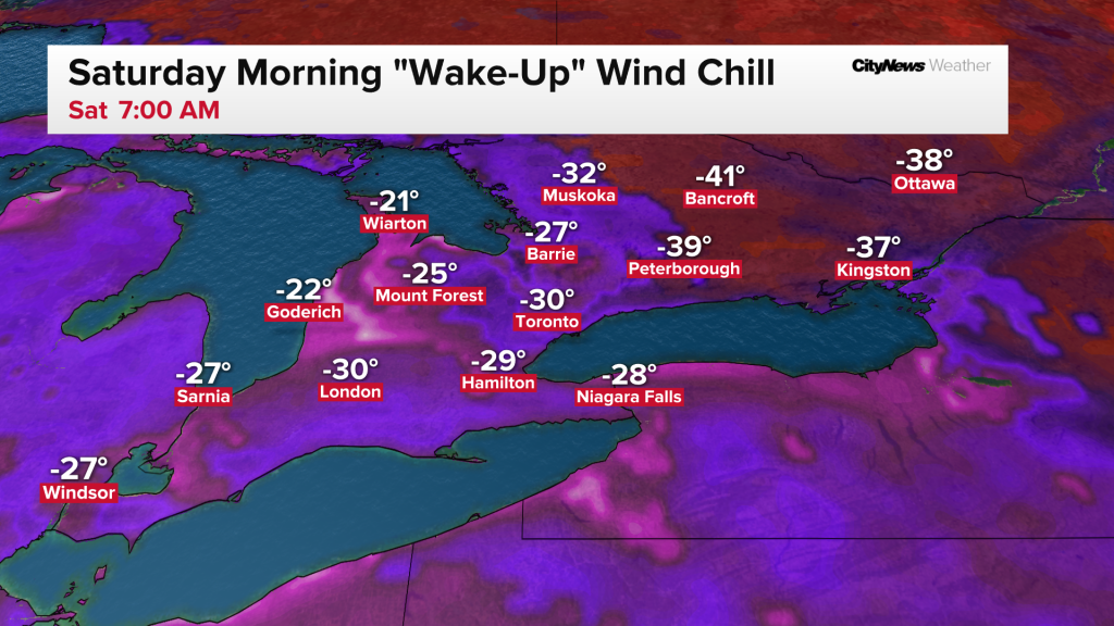
Meteorologists say overnight lows will drop into the –20s, with wind chills plunging close to -30 across the GTA. The combination of extreme cold and persistent wind will create dangerous conditions, especially for anyone without adequate shelter.
Public health officials typically issue Extreme Cold Warnings when wind chills fall below –30, and forecasters expect those alerts to be in effect through Saturday morning.
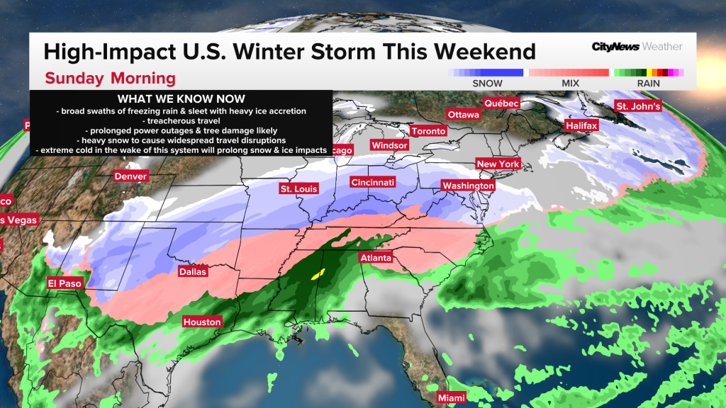
The bitter cold is only the first part of a larger weather system that is set to affect hundreds of millions of people across North America. The same storm bringing crippling ice and heavy snow to parts of the United States will track toward southern Ontario on Sunday.
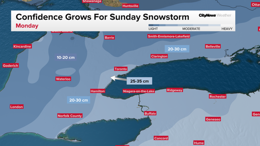
Heavy snowfall forecasted for Toronto, GTA
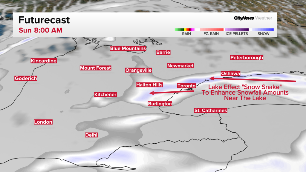
Before the system snow reaches the GTA on Sunday afternoon, there will likely be a heavy lake-effect “snow snake” targeting areas near the lake, with an initial 5-10 cm early Sunday morning. The system itself will then start just before noon on Sunday, and total amounts near the lake, including downtown Toronto, could be in the 25-35 cm bullseye.
“The snow-to-liquid ratio will be very high, leading to light, fluffy snow. This type of snow could easily pile up with localized amounts surpassing 40 cm near the lake,” says CityNews Chief Meteorologist Natasha Ramsahai.
Snowfall estimates for the north GTA are currently in the 15-25 cm range, and further north, snowfall amounts drop to 5-15 cm. The system will leave flurries in its wake for the Monday morning commute which is expected to be a very difficult and slow one.
Forecasters caution that totals will continue to shift as the storm’s path becomes clearer, and neighbourhood‑specific predictions are not yet possible.
Areas closer to the lakeshore, including downtown Toronto, are expected to see the highest accumulations as winds off the lake will create a “snow snake” that is expected to enhance snowfall totals. Because temperatures will remain extremely cold, Sunday’s light, fluffy snow will easily be blown around, potentially reducing visibility and complicating travel.
What to expect:
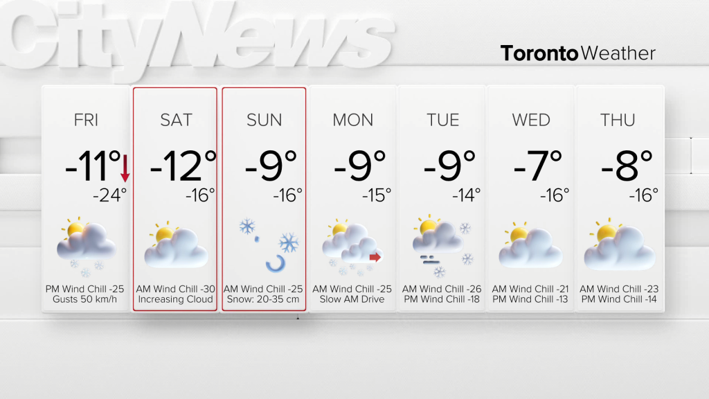
Friday night into Saturday morning: Life‑threatening wind chills near -30. Frostbite is possible in minutes.
Saturday: Bitter cold continues, though slightly less extreme than overnight.
Sunday into Monday: Significant snowfall likely, with 25-35 cm possible depending on storm track. Less snow for the north GTA.

Click here to sign up for the CityNews Weather Guarantee and to check out Toronto’s extended forecast.