Toronto to see big warmup on heels of coldest morning of the fall so far
Posted October 23, 2023 6:46 am.
Last Updated October 23, 2023 7:16 am.
GTA residents are waking up to the coldest morning of the season so far on Monday, but a warmup is on the way with the outside chance of record-breaking warmth later in the week.
Environment Canada issued a frost advisory for the City of Toronto, Peel Region and Halton Region, with the overnight and early morning temperatures marking the coolest point of fall up to this point.
CityNews 680 meteorologist Jill Taylor says the frosty conditions will be short-lived.
“It is a cool frosty start to Monday, you may have to give yourself extra time to scrape that frost of your windshield,” she says. “But this is just a brief cooldown for us.”
Cool frosty start to our week but a warm up is on the way! Find out how warm by tuning in
— 680 NewsRadio Toronto Traffic & Weather (@NewsRadioTO) October 23, 2023https://t.co/njTDOtKL84 E
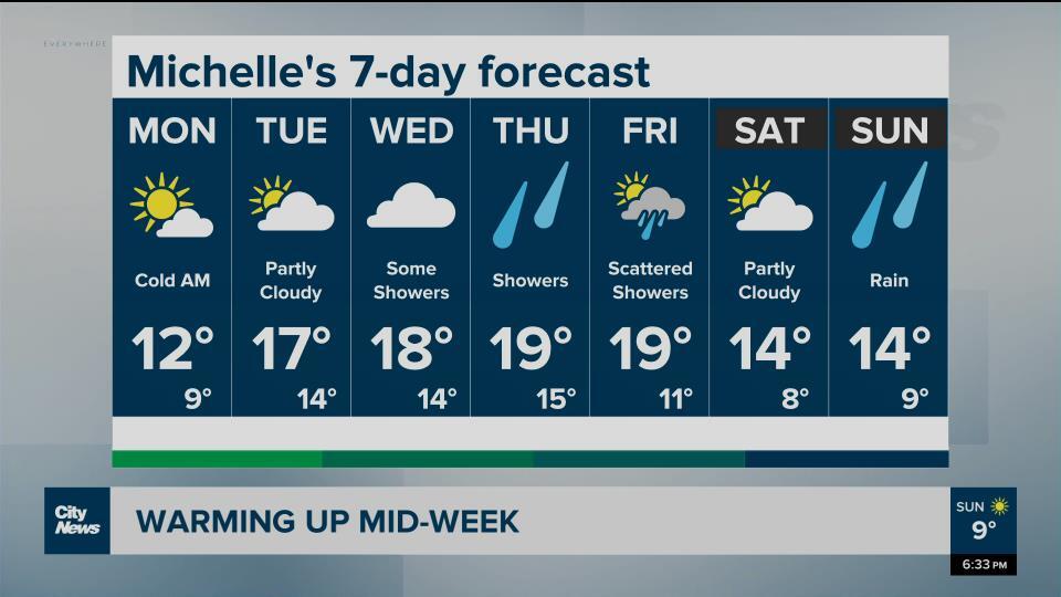
Things will heat up rather quickly Monday to reach a guaranteed high of 13 C, with mainly sunny skies. Then the real warmup begins with daytime highs from Tuesday to Friday expected to hover around 20 C.
Taylor says it’s even possible we could see a record high on Friday. The current record-high on Oct. 27 in Toronto was 22.7 C set in 2000.
Monday’s overnight cool down saw Toronto Pearson hit 0 C at 3 a.m., and Mississauga and Milton hit 1 C as of 5:30 a.m. It was even cooler in areas north of the city with temperatures in Muskoka dipping down to -4 C.
The average first frost day for Toronto is Oct. 16.
Click here for Toronto’s current conditions and the extended forecast.