Rivers recede as B.C. faces prospect of ‘unfamiliar territory’ for drought

Parts of British Columbia will likely enter “unfamiliar territory” with drought if they see another hot, dry summer, says the head of the province’s River Forecast Centre.
Dave Campbell says persistent drought conditions in B.C. stretch back to 2022, so the province is heading into this summer with “multi-year” precipitation deficits.
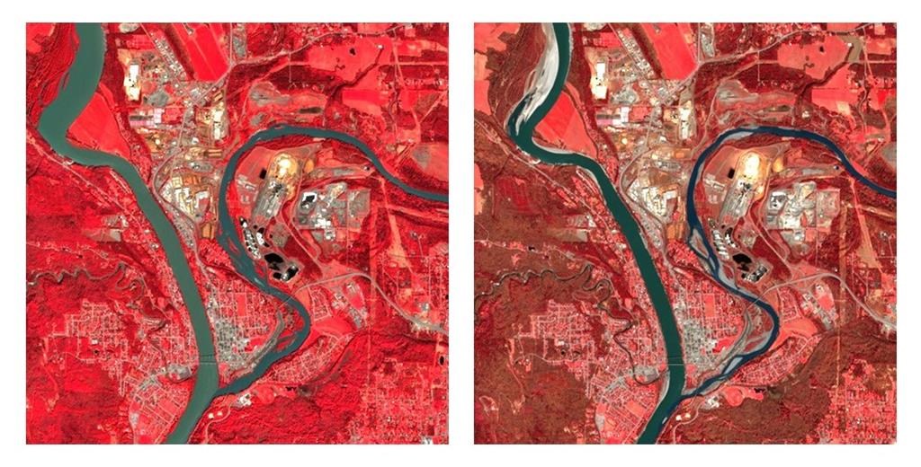
Satellite photos show rivers in the Interior running narrower and shallower than the same time in 2023, which went on to be one of B.C.’s driest years on record.
Advertisement
With the average snowpack level lower than ever recorded in B.C., Campbell says he’s expecting cumulative effects that could include water scarcity.
“We know these antecedent conditions that we’re coming into this year are much more challenging than we started out last year with,” he said in a recent interview.
“The concern obviously is if we get that hot, prolonged dry (period) that we’ve seen last year and the year before as well. If that continues this summer, then really we are on a path toward things that we haven’t seen in recent memory.”
B.C. officials held a news conference on Thursday to announce several new measures to help people prepare for threats such as drought and wildfires, which include an online tool for household emergency planning, an updated drought information portal and upgrades to the BC Wildfire Service mobile app.
Nathan Cullen, minister of water, land and resource stewardship, said the province is facing a “serious” situation with the potential for continued drought, and he asked people to take steps to reduce their consumption to conserve water.
Advertisement
“Every drop counts,” he said.
Emergency Management Minister Bowinn Ma said people often underestimate how their individual consumption adds up. During the peak summer months, residents of Metro Vancouver consume between 1.5 and 1.8 billion litres of water each day.
“This is an extremely challenging amount to envision,” she said.
Ma said she recognizes there may be questions about large industrial users, but “nobody gets a free pass on this.”
“Those companies, those industries, they are regulated, and they will be affected, if necessary, as well.
Advertisement
“But we as individuals, as households, we have a role to play,” she said.
The province also released its latest snowpack bulletin on Thursday, which says levels are “extremely low,” averaging 66 per cent of normal for this time of year.
The bulletin says many low- to mid-elevation areas in the Interior are now free of snow.
Much of B.C. saw below-normal precipitation levels in April, the bulletin says, with some smaller pockets recording near-normal amounts.
The next three days are expected to bring temperatures that are “well-above normal,” leading to the first episode of rapid melting at higher elevations, it says.
Advertisement
Parts of the Interior are especially dry. Campbell said he’s most worried about the effects of drought on smaller rivers and creeks in the central Interior.
“Prince George, Quesnel, Williams Lake, Vanderhoof, that’s kind of the hot spot, and then the other (area) that would be a concern would be up in the northeast,” he said.
The Vanderhoof area, west of Prince George, has seen about 220 millimetres of rain over the past year when it typically sees more than double that, he said.
Images provided by the Canadian Space Agency appear to show the effects of persistent drought in the Interior when compared with those taken last spring.
An image taken last week by aEuropean Space Agency satellite shows the Quesnel River is narrower, with more of its banks exposed compared with an image taken a year ago. The latest photo shows patches of exposed riverbed and sandbars, indicating lower water levels in the tributary as it meets the upper Fraser River in Quesnel, about 600 kilometres north of Vancouver.
Advertisement
Satellite images tell a similar story in Fort St. James, B.C., where the water appears shallower this year as Stuart Lake feeds into Stuart River.
The Fort Nelson and Muskwa rivers also appear narrower, with more of their banks exposed compared with images taken in April 2023.
The Canadian Space Agency notes the images use infrared “false colour” because it shows the boundaries between land and water more clearly than other renditions.
Campbell said parts of B.C.’s Okanagan will likely also see the effects of the moisture deficit and low amounts of snow that melted early this spring.
On northern Vancouver Island, he said Port Hardy has seen 1,260 millimetres of rain over the last year when it typically sees a little more than 1,800 millimetres.
Advertisement
It would take “a few months of wet-season rainfall” to make up that deficit, he said.
Forests Minister Bruce Ralston told the news conference on Thursday that dry conditions and warm weather in the forecast will likely spur wildfire activity. He said officials are keeping a close eye on northeastern B.C. in particular.
He said the BC Wildfire Service had dispatched an incident management team to establish a command centre in the Fort Nelson area.
“We’re preparing air and ground resources. Helicopters, air tankers, unit crews and initial attack crews are being brought in early,” he said.
Cliff Chapman, director of provincial operations for the BC Wildfire Service, said they’ve increased partnerships with First Nations and other local governments to use prescribed fire to help reduce the risks around communities this summer.
Advertisement
“Twenty years ago, when I started my career in BC Wildfire Service, many of the fires that we fought did not interact with communities,” he added.
“At this point in the life cycle of wildfires in British Columbia, almost every fire has an impact on somebody’s livelihood or it is adjacent to a community.”
This report by The Canadian Press was first published May 9, 2024.
Brenna Owen, The Canadian Press
Advertisement
