Polar Vortex to crash Mother’s Day Weekend
Posted May 4, 2020 7:12 pm.
This article is more than 5 years old.
With Mother’s Day weekend coming up, many folks are likely thinking it’s time to get some plants in the ground, but the mother of us all may be thinking otherwise.
Mother Nature and her good friend the Polar Vortex are coming to town this weekend and between the two of them, they could bring us record low temperatures and several frosty mornings around the GTA.
So keep those seedlings in the house for at least another week and maybe hold off on the trip to garden centre for your curbside pick up until we get into next week.
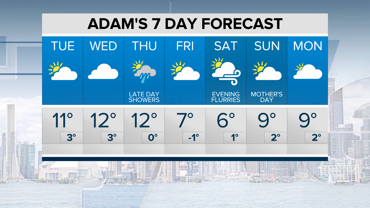
Here’s what the next seven days look like:
How rare is this type of cold weather?
Toronto hasn’t had a May temperature below the freezing mark since 2005’s month of May at Pearson Airport.
Where do the record lows stand?
The average low temperatures for this week over the past 30 years is about 5 to 6 degrees
Here are the lowest temps we’ve hit for this week in the past three decades:
May 5: -3.9 (1969)
May 6: -3.9 (1968)
May 7: -5.6 (1966)
May 8: -3.3 (1966)
May 9: -2.2 (1966)
May 10: -3.9 (1947)
Toronto’s best shot at breaking any of these record lows will come Friday and Saturday (May 8 and 9) with temperatures forecast to dip below freezing here in the city.
More not-so-great news
There is a risk of snow in the forecast to kick off the weekend.
The cold air and wind will come together on Friday and bring lake effect snow in the snow belts.
Toronto has the chance of seeing some flurries again on Saturday night with a weak system passing by. Don’t worry — it usually melts quickly this time of the year.
Why is it so cold?
It appears that the atmosphere is a bit plugged up and the blocking pattern that has plagued most of the spring vibes here in Toronto is still sticking around for at least another week or so.
While this is happening here, the west coast is destined for temperatures in the mid 20s in British Columbia’s lower mainland by the weekend.
So the heat building in the west is something that we could see as a sign of hope that when the blocking pattern breaks down or shifts out of the eastern half of North America, we may flip the switch and go straight into summer.
In the meantime the upper level steering winds or the Jet Stream are positioned well to our south. That allows the cold arctic air to descend south from the north and has us reaching for the layers this Mother’s Day weekend.
Any sign of this pattern breaking down?
In the long range, and I mean really long range (so don’t bet the rent on this one), there are signs that temperatures will start to come out of the cellar by the May long weekend.
They should at least get close to the seasonal daytime highs, which for this time of year are between 17 to 20 degrees.
But until then, the next 10 to12 days here in southern Ontario will be cool.