Flooding, damage reported across Greater Toronto Area amid record-breaking rainfall
Posted August 17, 2024 11:16 am.
Last Updated August 18, 2024 10:53 am.
A severe thunderstorm moving across the Greater Toronto Area brought record-breaking rainfall, resulting in multiple instances of flooding and damage.
“Pearson (International Airport) already reported 78 millimetres of rain this morning, so to put it into context we’ve got record-breaking rain today in Toronto,” Trudy Kidd, a meteorologist with Environment and Climate Change Canada, told CityNews Saturday afternoon as rain continued to fall in the region.
“A typical August at Pearson from 1991 to 2020 sees 68.5 millimetres, so that means we have seen a month’s worth of rain in one day.”
By the end of the day, 128.3 millimetres of rain fell. The previous daily record for moisture on Aug. 17 was 27.9 millimetres in 1932.
The storm system prompted meteorologists to issue a series of watches and warnings for southern Ontario Saturday morning.
David Sills, executive director of the Northern Tornadoes Project at Western University, confirmed a tornado touched down in the community of Ayr, Ont., around 11 a.m. on Saturday.
“The team has been in the area since the afternoon and is currently assessing the width, length, extent of damage and other data,” he said.
“We rate the tornadoes based on the damage they’ve caused.
“We’ve got trees down in every direction possible. … This one was on the weak side.”
Kidd said Environment and Climate Change Canada staff didn’t formally confirm a tornado touched down as of Saturday afternoon, but added personnel with the Northern Tornadoes Project would be gathering witness statements and other evidence to assist with their confirmation process.
There were no reports of physical injuries, but major damage was reported at a Home Hardware on the northern edge of the rural town located approximately 17 kilometres west of Cambridge.
As the morning and early afternoon progressed, the storm system moved east into the Greater Toronto Area where severe thunderstorm watches were upgraded to thunderstorm and rainfall warnings.
At around 1:30 p.m., images began surfacing on social media showing roads in Mississauga flooded with rain. Some of the images shared appeared to show vehicles almost totally submerged by water.
Peel Regional Police shared reports of dangerous conditions on the service’s X account.
Officers said Rathburn Road West near Elora Drive had major flooding and eastbound lanes from the intersection were being shut down. At the intersection of Mavis Road and Lafayette Drive, officers said the roads were covered with water. They urged residents to avoid both areas.
Videos and photos posted on the Mississauga Fire and Emergency Services X account appeared to show crews attending several other roads to respond to flooding.
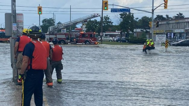
Close to a dozen people had to be rescued by firefighters from raging waters that had trapped motorists and pedestrians at Queen Frederica Drive and Dundas Street in Mississauga.
The Toronto Police Service also reported flooding on multiple roads in the city’s west end. The TTC also reported multiple routes were seeing diversions due to flooding.
The storm caused flight diversions and ground delays at Toronto Pearson Airport, its operator said on X, adding it’s having a major impact on passengers.
The rain also resulted in various leaks in Terminals 1 and 3, though both were still operational, the Greater Toronto Airports Authority said on X. The Terminal Link Train experienced a service disruption in the late afternoon due to water leaking on a platform, but has since returned to normal service, it added.
The Toronto and Region Conservation Authority issued a flood watch through the end of Sunday, saying all shorelines, rivers and streams within the Greater Toronto Area should be considered dangerous due to higher and rapidly changing water levels and unstable river banks.
Conservation Halton issued a flood outlook statement Saturday afternoon and said while widespread flooding wasn’t expected in its jurisdiction, fast-flowing water and flooding in low-lying areas were likely.
Meanwhile, Kidd said 100 millimetres of rain could fall by the end of Sunday in spots. She said the weather was expected to ease Saturday evening ahead of more rain on Sunday.
“Once you get hit with a slow-moving, moisture-laden thunderstorm, you’ll be seeing a lot of rain and we want people to be careful out there and pay attention,” Kidd said.
Click here to access the latest weather warnings and watches from Environment and Climate Change Canada.
Firefighters are assisting with localized flooding emergencies at Dundas and Queen Frederica. pic.twitter.com/IqzuZ4s5pr
— Mississauga Fire (@MississaugaFES) August 17, 2024
Firefighters assist stranded pedestrian clinging to the light standard in the area of Dundas and Queen Frederica. pic.twitter.com/C2OKVxcPhq
— Mississauga Fire (@MississaugaFES) August 17, 2024
As of 3:20 pm on August 17, be advised of the following road closures we are aware of: pic.twitter.com/tniGTRw8qf
— Mississauga Fire (@MississaugaFES) August 17, 2024
HAZARD:
Wilson Ave and Wendell Ave
3:47 pm
-reports of flooding on Wilson Ave underneath bridge
-2 vehicles stuck in water
-police o/s
Road closures in effect:
Wilson Ave closed
W/B at clayson Rd
E/B at Wendell Ave
-avoid the area#GO1800429
^lm— Toronto Police Operations (@TPSOperations) August 17, 2024
HAZARD:
Kipling Ave and Belfield Rd
1:55 pm
-reports of flooding under the bridge
-manhole damaged and water coming out
-police o/s
-avoid the area#GO1800481
^lm— Toronto Police Operations (@TPSOperations) August 17, 2024
HAZARD:
Martin Grove Rd and Bethridge Rd
2:24 pm
-flooding on the roadway under the bridge
-one vehicle stuck in water
-police o/s
-avoid the area#GO1800660
^lm— Toronto Police Operations (@TPSOperations) August 17, 2024
HAZARD:
William Cragg Dr and Jane St
2:49 pm
-intersection is flooded
-two vehicles stuck in water
-police and Toronto fire are o/s
Road closures in effect:
-Jane St closed S/B at William Cragg Dr
-Jane St closed N/B at Wilson Ave
-avoid the area#GO1800821
^lm— Toronto Police Operations (@TPSOperations) August 17, 2024
HAZARD:
Weston Rd and Finch Ave
3:03 pm
-E/B lanes flooded
-no vehicles are stuck
-311 had been advised
Road closures in effect:
-E/B Finch Ave closed at Weston Rd
-W/B Finch Ave at Signet Dr
-avoid the area#GO1800934
^lm— Toronto Police Operations (@TPSOperations) August 17, 2024
City of Toronto now under a Severe Thunderstorm Warning from @ECCCWeatherON. Review your plans including travelling in elevators and on roads which can be affected by power outages and water accumulation. Be prepared. Be safe. #toronto ^dc https://t.co/rwqoiJz0Dl
— Toronto Fire Services (@Toronto_Fire) August 17, 2024
A possible tornado has touched down in the Greenfield Road/Northumberland Road area of Ayr. Please note that the NDCC and Cowan Park are CLOSED. We ask that people stay away from the area of Greenfield/Northumberland as emergency crews are on site. (photo from Jake Nagle) pic.twitter.com/wr6g46ZhsJ
— Township of North Dumfries (@northdumfries) August 17, 2024
STORM UPDATE:
– There are reports of a tornado touching down in Ayr.
– Damages to the roof of the Home Hardware. The business has been evacuated, and no physical injuries were reported. North Dumfries Fire is attending due to smell of natural gas at this location.
– ROAD… pic.twitter.com/qQlDsMAYaq
— Waterloo Regional Police (@WRPSToday) August 17, 2024