Southern Ontario braces for more snow this weekend
Posted November 28, 2025 8:49 am.
Last Updated November 28, 2025 8:42 pm.
Southern Ontario is expected to continue experiencing winter weather conditions on Friday, as lake-effect snow squalls off Lake Huron and Georgian Bay impact parts of the region.
The snow squalls that brought bursts of heavy snow and strong winds created difficult driving conditions and knocked out power to thousands of Hydro One customers. Crews continue to work to restore service to the affected areas.
Forecasters say northwest winds gusting between 40 and 60 km/h will persist through Friday evening, whipping up blowing snow and keeping wind chills sharp. Two dominant squall bands are expected to form, each targeting different areas.
Multiple bands are forecast to push southeast from Lake Huron, crossing Highway 21 near Goderich and stretching toward Kitchener-Waterloo, Cambridge, Stratford, Woodstock and Brantford. Drivers along Highways 401 and 403 should prepare for sudden whiteouts and accumulating snow, with the squall occasionally dipping into Hamilton and Brantford.
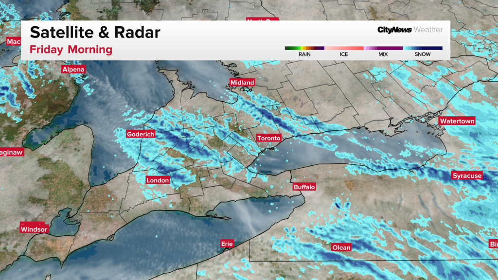
“This will be a long-duration event with snow squalls likely persisting into Saturday morning, particularly near Lake Huron. Strong westerly winds gusting to 70 km/h are also expected. These strong winds will reduce visibility to near zero at times in local blowing snow,” Environment Canada said.
As of Thursday morning, some parts of the Greater Toronto and Hamilton Area (GTHA) were under varying weather alerts, including Burlington and Oakville (special weather statement), Hamilton, Guelph, Halton Hills, Oshawa, Pickering and Uxbridge (snow squall warnings).
Farther north, another band off Georgian Bay has been persistently tracking directly into Barrie, Lake Simcoe and along Highway 400 toward the northeast Greater Toronto Area (GTA), including Oshawa, since last night. Communities outside the main squall zones will see scattered flurries through the morning. The squalls are expected to weaken and dissipate by Friday evening, though some lingering bursts may persist into early Saturday.
Toronto’s short-term forecast. Here is what to expect

Toronto is expected to avoid the worst of Friday’s squalls, though flurries remain possible.
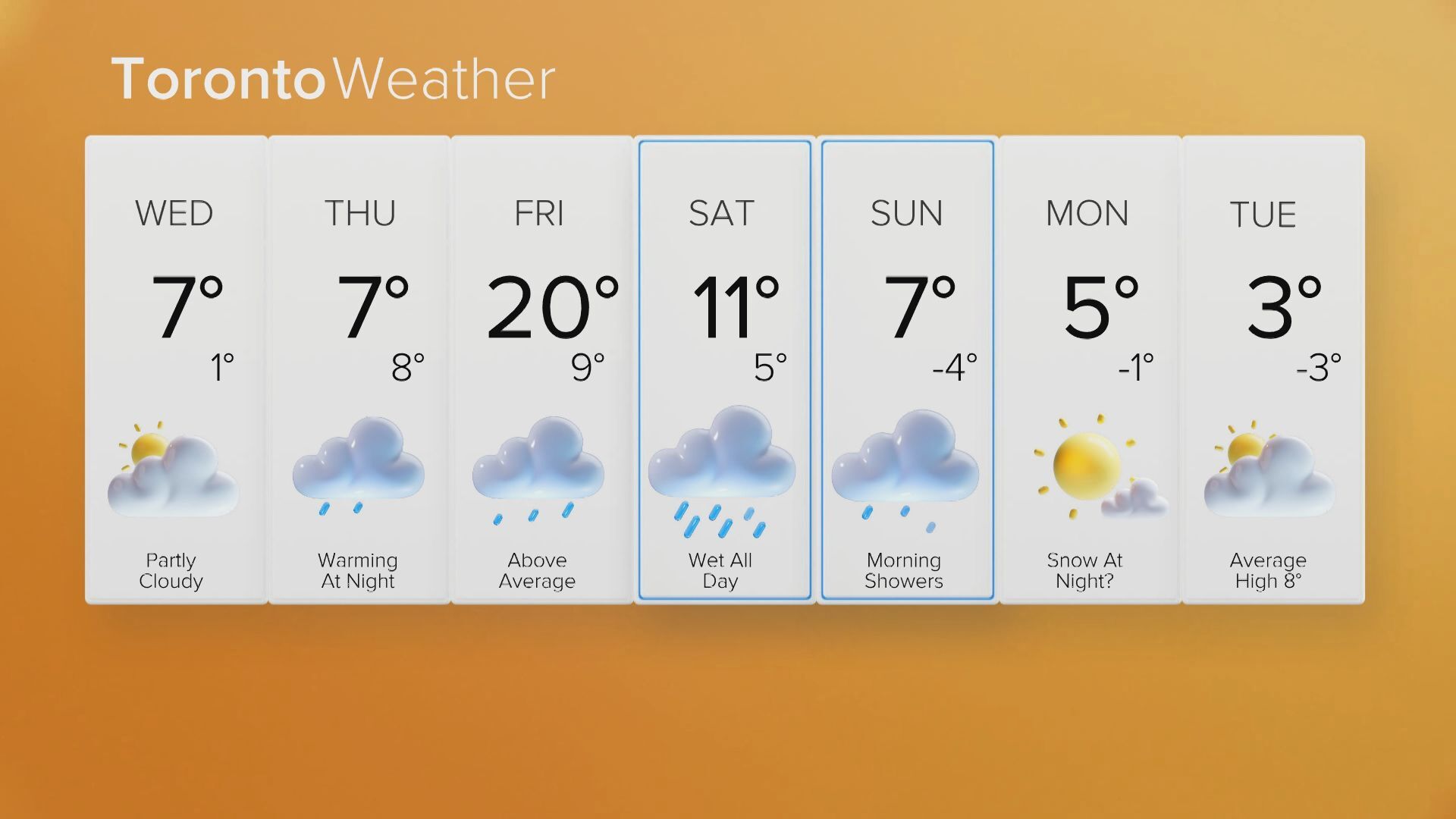
The city’s three-day forecast calls for mainly cloudy skies Friday with a 40 per cent chance of flurries, northwest winds gusting up to 50 km/h, and a high near 2°C. Wind chills were near -7 in the morning.
Overnight, conditions will turn partly cloudy with a 30 per cent chance of flurries, a low near -4°C , and wind chills dropping to -9.
Saturday will bring a mix of sun and cloud with a high of 1°C. Snow is expected to return Saturday night as a low-pressure system moves in, with temperatures hovering near -1°C. By Sunday, periods of snow are forecast with rain mixing in closer to Lake Ontario with a high of 3°C, before turning colder overnight, with a chance of flurries and a low near -5°C.
Another weekend system
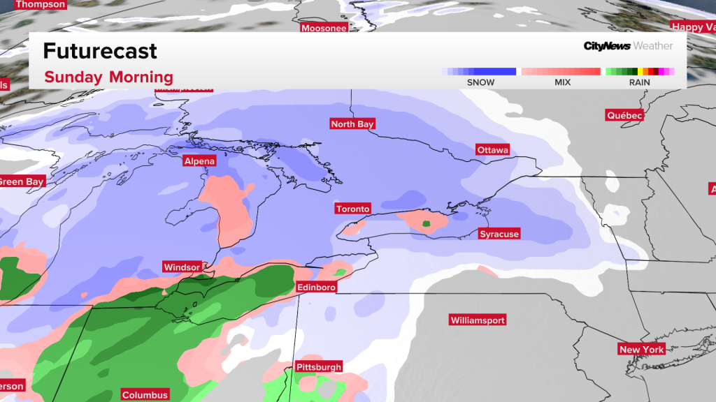
Attention is shifting to the next incoming system, a Colorado low projected to sweep into southern Ontario late Saturday and Sunday. The system will spread a more uniform layer of snow across the province, beginning near Windsor on Saturday evening before reaching the GTA overnight and Ottawa by early Sunday.
Communities in the snowbelt regions, already hit hard by Thursday and Friday’s squalls, could see an additional 10 to 15 cm of snow over the weekend.
For most of southern Ontario, widespread totals of 5 to 10 cm are expected, though areas along the shores of Lake Erie and Lake Ontario may see less if snow mixes with rain.
Click here to sign up for the CityNews Weather Guarantee and to check out Toronto’s extended forecast.