Why does Toronto see different types of precipitation at the same time?
Posted January 13, 2020 7:55 pm.
This article is more than 5 years old.
Toronto is the land of messy weather and some of the most complex winter storm systems.
From decent snow storms to rain for some and snow for others, to the “everything but the kitchen sink” type of storms – we have them all. But why?
Personally, I think it’s karma for all of the years I spent forecasting in the dessert of Utah and the coast of California, where I could pretty much phone in the forecast. All joking aside, this area does have some interesting storms, and it doesn’t take much to change the type of precipitation, as it is only a matter a couple of degrees difference.
So what is so special about the Toronto area?
To help answer that, let’s play a game: Know your precipitation type — aren’t you thankful you don’t invite me to any of your parties?
We typically see or forecast for four main types of winter precipitation: snow, freezing rain, ice pellets and rain. There are a few variations or off-shoots of those main four that you many have heard of, but I’m going to keep it simple and stick to those for now.
Here is a very simplified look at what is happening in the atmosphere in terms of temperatures as each precipitation type is falling to the ground. In the graphic below we are using the terms “warm air” as warm enough to melt frozen precipitation and “cold air” as cold enough to freeze falling precipitation in the air or when it makes contact with the ground.
Let’s walk through it from left to right:
In many cases, everything starts out as a snowflake or piece of ice way up in the atmosphere at the top of the clouds.
When it comes to rain, we typically will see a column of warm air that is high or deep enough between the ground and melting point in the sky (from where the snowflakes start to melt) that keeps the rain drops in the liquid state from melt to splashdown. Also, did you know that rain drops are shaped more like burgers or a pancake when they are falling instead of the classic raindrop shape? (Leave it to me to make a food comparison to a rain drop!)
As for snow – I think you get the drill with snow – snowflakes staying in cold enough air to remain a snowflake. While it seems simple, I briefly explain a few of the differences in snowfall types in a previous article found here.
But hands down, the absolute worst winter precipitation is freezing rain, but it is probably the one that is also the most mistaken.
When someone says that they can hear the freezing rain bouncing off the window they aren’t talking about freezing rain. Freezing rain is pretty much rain until it hits the frozen ground.
The only difference between rain and freezing rain is the very shallow layer of cold air hanging near the ground that cools the surface to below freezing, but isn’t deep or high enough to freeze the rain drop before it hits the ground. If it were deep enough, it would be ice pellets.
Did you know that water can drop to below freezing without actually becoming a solid?
This is a process known as super cooling, where water stays as a liquid with temps below 0 degrees, until it comes into contact with other ice crystals or the ground.
Why is freezing rain the worst type of winter precipitation? Because it looks like rain, but creates treacherous driving and walking conditions. Not only that, if you remember the ice storm from a few years ago, then you know the type of damage these storms are capable of. It can lead to power outages that last several days, if not weeks along with a host of other problems.
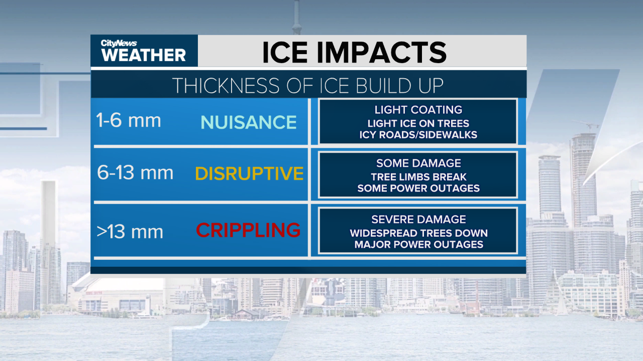
Here is a breakdown of the type and amount of ice and their impacts:
Ice
Ice is pretty heavy and it puts a lot of stress and weight on hydro lines and tree branches. Typically hydro lines are designed to hold the weight of 13 millimetres of ice and some wind up to 65 km/h. Anything more than that is pretty catastrophic. For example in the 2013 Toronto ice storm, we saw roughly 30 millimetres of ice.
Ice pellets
Ice pellets or, as our American friends call it, sleet, are the type of precipitation that you can hear clattering off the window. These are basically snowflakes that melt on their way down and then refreeze into tiny ice balls. They are much different that hail though, because hail forms in the updraft of a storm and stays frozen from the top of the cloud to the ground. Ice pellets are more of a nuisance than anything and a significant round of ice pellets can make for hazardous travel and back-breaking shovelling.
Why does the Toronto area see differing precipitation on the same day?
There are many things at play here — from our geographic location, to the Great Lakes, to subtle elevation changes around the region.
It seems there is a magic line around the 401 or Steeles where rain magically turns into snow — well sort of. That is where we start to climb in elevation which generally means the air is cooler.
The lake temperatures and wind direction also plays a role in how shallow or how deep of a cold layer can form at the surface. That is why many forecasts vastly differ from lakeside to north of the 401 when temperatures are close to the freezing mark.
