Extreme cold weather alert issued in Toronto as temperatures plunge
Posted December 22, 2022 10:24 pm.
Last Updated December 24, 2022 7:25 am.
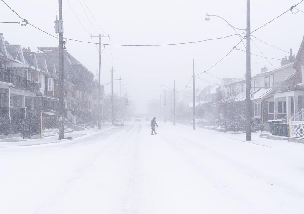
An Extreme Cold Weather Alert is in place across Toronto as temperatures dip to dangerous levels over the next few days.
Gusting winds, which are part of the winter storm system sweeping across southern Ontario, will contribute to very cold wind chill values in the minus 20s Friday evening and into the weekend.
As a result the City of Toronto announced Friday it would be expanding capacity at its warming centre at Metro Hall to almost double in the wake of the cold weather.
Listen to CityNews 680 LIVE now!Winter storm and blizzard warnings remain in place throughout much of southern Ontario but warnings have been downgraded to winter weather travel advisories.
Wind gusts up to 90 km/h will result in widespread blowing snow in GTA which will reduce visibility to near zero at times. The snow will taper to flurries on Saturday but the winds are not expected to subside until the evening.
Hydro One, the province’s largest electricity utility, said they were responding to “significant” power outages as high winds hit regions across the province. More than 73,000 customers were without power as of 11 p.m., and the utility warned some customers will be without power overnight.

Toronto Hydro was not reporting any significant outages as of 11 p.m. but said all available resources were on standby, ready to respond.
Tory warns Toronto storm cleanup will take several days
Mayor John Tory is warning that cleanup from the storm could take several days due to the rain and wind that is expected to accompany the snow and ice.
“The most effective thing we can do is to urge people to stay home,” Tory says. “It’s hard because a lot of people have Christmas shopping to finish and are going to visit loved ones.”
Tory is also advising residents to keep an eye out for downed power lines and to check in on vulnerable family and friends during the storm.
Toronto Mayor John Tory says this winter storm is unique with potentially damaging winds and rapidly falling temperatures. #TOpoli pic.twitter.com/iL1SdPKwvf
— Kevin Misener (@Kevin_Misener) December 23, 2022
The city’s Director of Operations and Maintenance Vincent Sferrazza says every piece of equipment of the city’s disposal is ready to be deployed but warns crews are in for a trickier than usual clean-up.
“Because it’s going to be raining, applying liquid brine will be less effective, it’s just going to wash off,” Sferrazza says, noting crews typically apply the brine before a snowfall or frost arrives.
The city says it has deployed crews to “strategic and high-priority locations around the city” in an effort to respond to transitioning precipitation as quickly as possible.
The strong and potentially damaging winds expected to accompany the rain and snow could make the salting process more difficult with strong gusts potentially blowing the salt right off of roadways.
“We’re going to hopefully have the opportunity to do multiple rounds of salting,” Sferrazza says.
Crews have already begun clearing sidewalks and bike lanes and will begin plowing different roadways as the snow accumulates. Expressways will be plowed at two-and-a-half centimetres, major roads at five centimetres, and residential streets at eight centimetres
Most of eastern Ontario got 10 centimetres of snow, while some parts of the region, like Pembroke, Ont., got up to 20 cm, said Peter Kimbell, a meteorologist at Environment Canada. Ottawa received about 10 cm.
In places like Windsor, Ont., where a blizzard warning was in effect Friday evening, Kimbell said the worst was likely over – though blowing snow was expected to continue.
“The very southwestern part of Ontario, the worst is gone, but it’s going to continue to be nasty for some time, for another 12 hours or so,” he said late Friday afternoon.
Files from The Canadian Press were used in this report