‘Thundersnow’ phenomenon as intense winter storm slams Toronto
Posted March 2, 2023 6:47 am.
Last Updated March 3, 2023 11:39 pm.
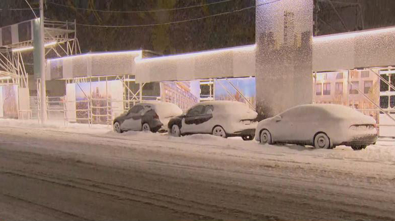
Another major storm blanketed Toronto and the GTA Friday leading to numerous preemptive public transit and airline cancellations and altered schedules.
Toronto and the GTA were under a winter storm warning with “rapidly accumulating snow” causing dangerous travel conditions.
“The snow is coming down hard in the GTA and will continue for the rest of the evening and overnight,” said OPP Sgt. Kerry Schmidt, who took to social media to update the deteriorating driving conditions. “Our collision reporting centres are getting busy as well, crashes coming in across the region. If you don’t need to be on the roads, stay home, wait for the system to pass. If you are going to be driving anytime in the next 12 or more hours, drive with extreme care and caution.”
Not only is the snow coming down at an accelerated rate, but the GTA experienced something not often see or heard – thundersnow, which is snow accompanied by a mix of thunder and lightning.
Yep, we’re getting into the heaviest part of the winter storm now and yes, we have thundersnow! ⚡️ pic.twitter.com/O7IiAYyhs1
— Natasha Ramsahai (@CityNatasha) March 4, 2023
The Toronto Transit Commission (TTC) says 41 bus stops located in hilly areas and known to be trouble spots due to icy conditions have already been taken out of service until further notice.
Line 3 Scarborough was taken out of service as of 7 p.m. until further notice with shuttle buses running between Kennedy and McCowan stations.
Extra bus service has been added to 10 bus routes starting Friday evening and continuing until Saturday morning and express bus routes that operate where there is local service may also be adjusted to serve all stops to ensure no customers are left behind on those corridors.
As well, the TTC has cancelled a full closure on Line 1 between York Mills and Bloor-Yonge that had been previously scheduled this weekend.
Extreme Weather Centre: Cancellations, closures, traffic and transit updates
Airlines prepare for storm
As of 11 p.m., Toronto Pearson Airport says 25 per cent of all flights – 109 departing and 121 arriving – had been cancelled Friday.
WestJet says it has cancelled all scheduled flights operating to and from Pearson as of 8:00 p.m. Friday. The airline says it hopes to resume flights Satuday morning “at a reduced capacity, contingent on weather conditions improving as forecasted.”
Air Canada says a travel advisory is in effect and that flights may be impacted by forecasted winter conditions. Customers are being asked to check their flight status before heading to the airport. As well, customers travelling on an affected flight will be able to make changes to their booking without penalty, space permitting.
Billy Bishop Airport says the storm is likely to impact its operations out of Pearson Airport and is asking customers to check their flight status and updates and give themselves plenty of time to travel to the airport. Many of their departing flights as of 7:30 p.m. Friday have already been cancelled.
Heaviest snowfall rates have been pushed later by about an hour. I'm pegging it between 9pm-1am now…this is the most important time window to stay off the roads. Sorry, the club will have to wait k? #onstorm pic.twitter.com/p6zLWSaP3U
— Natasha Ramsahai (@CityNatasha) March 3, 2023
‘Insane’ snowfall rates expected
The snow started falling just after 7 p.m., accompanied by wind gusts of up to 80 km/h in some areas producin near zero visibility on the roads. The heaviest snow is expected between 9 and 1 a.m.
There is the potential for up to 30 centimetres of accumulation in parts of the GTA by early Saturday.
Snowfall rates will hover around three to four centimetres per hour, and could be as high as six per hour during the peak of the storm. Taylor says the snowfall will be intense enough that thundersnow is a possibility.
"Snowfall rates" are more important when talking about IMPACT vs. "total snowfall amounts".
It's not the total snowfall of 20-30 cm that's the issue. It's the fact that most will fall in a short period of time (4-6 hours) with winds up to 80 km/h giving near zero visibility.
— Natasha Ramsahai (@CityNatasha) March 3, 2023
The snow will taper to flurries by around 9 a.m. Saturday with warmer air to close out the weekend. A high of 6 C is expected on Sunday.
The warming centre at Metro Hall is currently open and the City says three other centres at Scarborough Civic Centre, Mitchell Field Community Centre, Cecil Community Centre have opened as of 7 p.m. Friday night.
Related:
Toronto saw snow and gusting winds earlier this week that left several centimetres on the ground and a slippery Tuesday morning commute. It followed a messy winter storm last week that dropped snow and ice pellets across the city, causing travel delays as well some school closures and bus cancellations.
The latest storm is fueled by the same system that buried parts of California in several feet of snow in recent days. The system will make its way north from Texas and has left millions of Americans under weather warnings.
“This system will intensify over the Texas area, becoming a very strong Texas low,” Taylor says. “It picks up more moisture and then it moves towards us, making that impact for pretty much all of southern Ontario.”
The Weather Network’s spring forecast suggests the incoming winter storm is something we should be getting used to in southern Ontario. Spring officially arrives on March 20, but according to the spring forecast, March and parts of April will bring periods of colder-than-normal temperatures and “messy winter weather.”
The colder-than-normal spring conditions are expected to trend across most of the country.