Icy conditions expected in Toronto, GTA as temperatures drop following heavy rain
Posted March 6, 2025 6:34 am.
Last Updated March 6, 2025 6:40 am.
The morning commute in Toronto and the GTA is expected to be impacted by icy conditions due to a sudden drop in temperatures following periods of heavy rain.
Environment Canada issued a winter weather travel advisory for Toronto on Thursday, with strong winds also in play this morning.
“Ponding water or wet surfaces can freeze, creating icy and slippery conditions. Wind gusts up to 70 km/h are possible around the Greater Golden Horseshoe, and gusts up to 80 km/h are possible for southern Niagara,” Canada’s weather agency said.
“Icy conditions are expected to develop this morning. The strong winds will develop this morning, easing late in the afternoon or early in the evening.”
As the rain storm moves east out of the province on Thursday, temperatures will drop significantly, causing rainfall to transition into blowing snow across parts of southern and eastern Ontario.
“Motorists should expect hazardous winter driving conditions and adjust travel plans accordingly,” Environment Canada said. “Surfaces such as highways, roads, walkways and parking lots may become icy and slippery.”
Weather alerts currently span the province, with flash freeze warnings in Barrie, Bracebridge, Caledon, Kitchener, Guelph and Orillia, among other regions.
Mississauga, Brampton, Burlington, Oakville, Hamilton, Vaughan and Markham are also under winter weather travel advisories as of Thursday morning.
Winter temperatures follows heavy rainfall
Up to 25 millimetres of rain accumulated in the city on Wednesday. This prompted the Toronto and Region Conservation Authority (TRCA) to issue a Watershed Conditions Statement this week, warning that flooding from the river systems is possible in TRCA watersheds due to rain and snow/ice melt.
Ontario started to emerge from the deep freeze on Monday, with a sudden warm-up driven by an approaching system from the U.S.
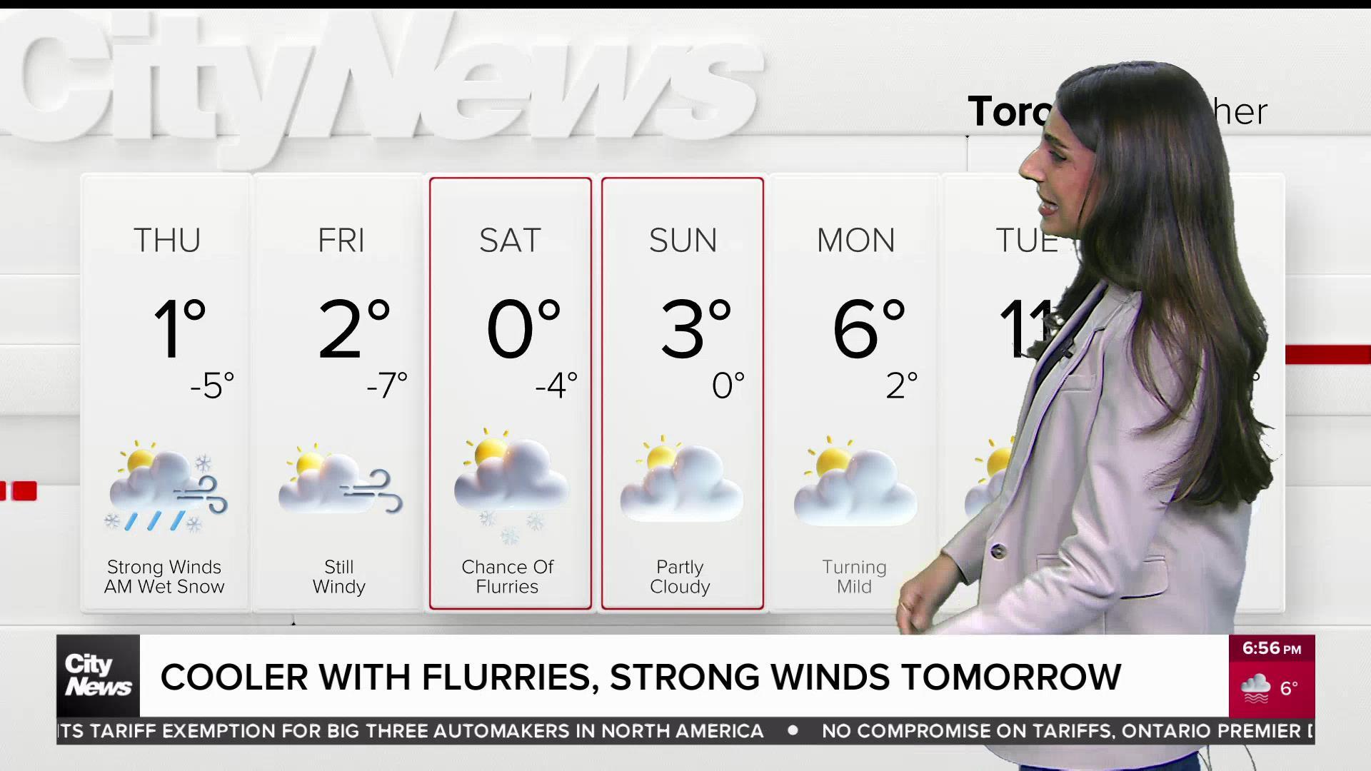
For Toronto, Thursday’s temperatures will drop gradually, becoming -3 C by the afternoon and feeling more like -9 with the windchill. It will warm up slightly on Friday, with the daytime high hovering around -1 C to the freezing mark, accompanied by sunny skies.
Similar conditions will be experienced in Toronto for the weekend, with a forecasted warm-up on Sunday of 2 C.
Click here to sign up for the CityNews Weather Guarantee and to observe the extended forecast.